
 (VINnews) — A powerful coastal storm — a Nor’easter — is expected to impact the Tri-State area beginning Shabbos morning and lasting through Monday, bringing strong winds, heavy rain, and hazardous coastal conditions. The timing is expected to seriously affect Chol Hamoed, Hoshana Rabbah, and Shemini Atzeres, with forecasters warning of dangerous weather throughout New York and New Jersey.
Subscribe to our Daily Roundup Email
Meteorologists say a strong low-pressure system will develop off the Southeast U.S. coast on Saturday and move northward along the Atlantic shoreline, intensifying as it approaches. High pressure over eastern Canada will funnel powerful northeast winds into the region, creating the classic Nor’easter setup.
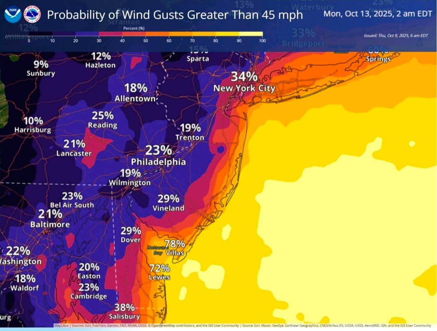
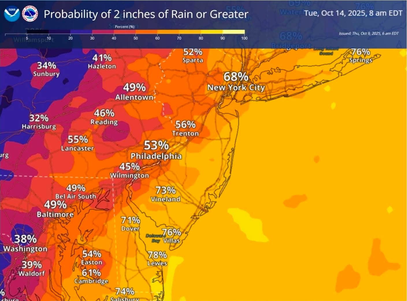
Forecast models indicate that winds will steadily increase through Shabbos, reaching full intensity by Sunday, when coastal areas could see gusts between 50–60 mph and heavy rain. The heaviest downpours and strongest winds are expected from Sunday evening into early Monday, before slowly easing by Tuesday morning.
Shabbos: Onshore winds develop; clouds and light rain begin.
Sunday morning: Steady rainfall and increasing winds.
Sunday afternoon–evening: The storm intensifies; gusts 35–45 mph inland and 50–60 mph near the coast.
Sunday night–Monday morning: Peak storm intensity with serious possible power outages, flooding, and coastal impacts.
Monday afternoon–Tuesday: Gradual improvement; breezy conditions persist near the shore.
The storm’s timing coincides with the final days of Sukkos, posing particular challenges for those continuing to use their sukkah through Hoshana Rabbah and beyond. Forecasters note that winds above 25 mph can begin to shift or overturn sukkahs, especially lighter or unsecured ones.
Halachic guidance: In situations where weather conditions make sukkah use unsafe, community members are advised to consult a Rav regarding what to do, rather than taking down or modifying the sukkah on their own.
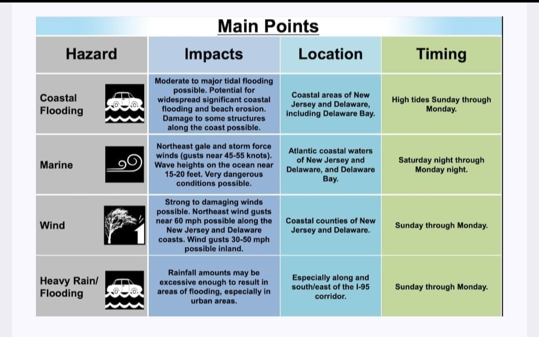
Wind Damage: Gusts may topple trees, knock down power lines, and create travel hazards.
Rainfall: Widespread rain totals of 2–4 inches or more could lead to localized flooding.
Coastal Flooding: High tides combined with strong onshore flow may cause beach erosion and minor coastal flooding.
Power Outages: High winds and saturated soil may result in scattered outages, especially in coastal and wooded areas. Think about this as your planning Yom Tov meals.
Authorities have already issued High Wind Watches for portions of Brooklyn, Queens, Long Island, and coastal New Jersey, warning that travel could be dangerous during the storm’s peak.
Residents are encouraged to secure outdoor items before Shabbos, ensure flashlights and batteries are ready, and stay informed through weather alerts prior to Yom Tov. Those living near the coast should be aware of high tide cycles and possible flooding impacts.
“This looks like a textbook Nor’easter — prolonged onshore winds, heavy rainfall, and possible coastal flooding,” said one forecaster. “The key concern will be safety, especially with gusts strong enough to cause damage.”
A Nor’easter is a type of storm that forms when cold air from the land meets warm, wet air from the ocean. The two air masses mix together, causing the air to spin and create a powerful storm.

Keep plastic bottles of frozen water in your freezer to keep your food cold inside the freezer in case you don’t have power. Charge up your power boosters for cell phone. Have some clocks working on batteries instead of plug in power.